



Field Team Geolocation and Resource Tracking
See where your teams are, what they are working on, and how to get the next job done faster.
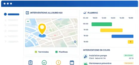
Visual Planning's geolocation feature gives operations managers and field coordinators a live map view of team positions, active interventions, and resource locations — connected directly to scheduling so every decision is based on what is actually happening in the field.

Clear Visibility Over Every Field Operation
Team Location
Visualize field team positions in real time to track active interventions and improve coordination across every service area.
Intervention Tracking
Locate assignments and field movements to maintain a clear view of what is happening across every active job site or service zone.
Geographic Scheduling
Organize interventions based on resource location to optimize routing and cut unnecessary travel time between assignments.
Optimize Field Operations With Location-Based Scheduling
Geolocation makes field intervention planning more effective by accounting for the actual position of teams and resources — not just theoretical availability.
✓ Visualize interventions and assignments on an interactive map
✓ Schedule missions based on resource location and proximity
✓ Reduce travel time between interventions
✓ Improve route organization by geographic zone

Improve Field Team Coordination in Real Time
Geolocation eliminates the coordination gap between field teams and operations managers — no phone calls, no manual status updates.
✓ Track field activities in real time from the office
✓ See available teams and their current location at a glance
✓ Distribute interventions based on proximity to the job
✓ Adjust scheduling instantly when field conditions change
Geolocation Connected to Scheduling and Resource Management
Visual Planning's geolocation is connected directly to activity scheduling and resource management. It is not just a map — it is an operational decision tool.
✓ Associate interventions with a precise location on the map
✓ Schedule missions by geographic zone and resource availability
✓ Track field activities on the map alongside the operational schedule
✓ Coordinate teams and resources from one unified view

Geolocation and Mobile Field Access
Visual Planning's geolocation lets field teams associate their interventions and activities with a location — making mission organization straightforward from any mobile device.
Teams log their position during interventions so managers can visualize activities on the map and track movements between assignments in real time.

Built for Every Role in Field Operations
Visual Planning's geolocation feature can be used by various roles within the organization.
Leadership and Managers
Track field activity and visualize operations on a live map without leaving the office.
✓ Maintain a global view of all field activities across service areas
✓ Track active interventions in real time
✓ Analyze geographic coverage and team distribution
✓ Make faster decisions based on accurate field data
Operations Managers
Coordinate teams and optimize intervention organization from a centralized map view.
✓ Plan field interventions based on team location
✓ Distribute assignments based on proximity to each job
✓ Track movements and travel time across the fleet
✓ Improve cross-team coordination in real time
Resource Planners
Organize missions based on resource location to optimize every route and reduce wasted travel.
✓ Schedule interventions by geographic zone
✓ Optimize routes to minimize travel between assignments
✓ Eliminate unnecessary travel between missions
✓ Improve field resource utilization across service areas
Field Teams
View your assignments, see your interventions on the map, and organize your movements — directly from your mobile device.
✓ Access planned interventions from smartphone or tablet
✓ View assignments on the interactive map
✓ Organize travel based on intervention sequence
✓ Log field activity progress and location updates in real time
Explore Other Visual Planning Features

Gantt Chart Views
Plan projects and track task dependencies with Gantt charts connected to resource management.
>

Kanban Boards
Organize tasks and visualize workflow progression at every stage of the process.
>
Geolocation
Supervise field teams and visualize resource locations on an interactive map.
>

AI Planning Assistant
Analyze scheduling data and improve decision-making with VPPilot.
>

Automated Scheduling
Optimize activity planning with VPAutomation's automated sequencing and scenario simulation.
>

Dashboards and Reporting
Analyze projects and resources with customizable dashboards and real-time reports
>
Field Team Geolocation
Frequently Asked Questions
What is geolocation in Visual Planning?
Visual Planning's geolocation feature associates field interventions and activities with a location on an interactive map. Teams visualize missions, travel routes, and intervention organization directly in the interface — connected to activity scheduling and resource management in real time.
Can Visual Planning display interventions on a map?
Yes. Visual Planning displays interventions, assignments, and field activities on an interactive map. Operations managers see in real time where teams are, which interventions are active, and how resources are distributed geographically across every service area.
Can Visual Planning define task dependencies in Gantt charts?
Yes. Visual Planning supports finish-to-start and start-to-start dependencies between tasks. The critical path is calculated automatically so project managers always know which tasks control the final delivery date — and where to focus attention when conditions change.
Does geolocation allow field team tracking?
Yes. Field teams log their location during interventions. Operations managers track movements and mission progress from the office — without phone calls or manual status updates from the field.
Can geolocation be used for field service management?
Yes. Visual Planning's geolocation connects directly to field intervention scheduling. Operations managers plan missions from the map view, assign available resources, and track intervention progress in real time — all from one unified interface.
Does geolocation integrate with other tools?
Yes. Visual Planning connects to your existing business tools via REST API — ERP, CRM, field service applications, and GPS telematics systems. Location data flows automatically between systems so your field view always reflects current conditions.
Your Teams Are in the Field. Make Sure You Always Know Where They Are and What They Are Working On.
Visual Planning helps you coordinate field teams, plan interventions, and track field activity with geolocation — connected to your live schedule in real time.